Preah Sihanouk Province
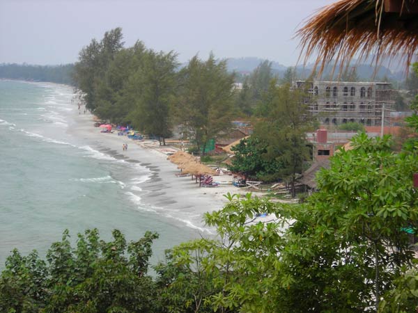
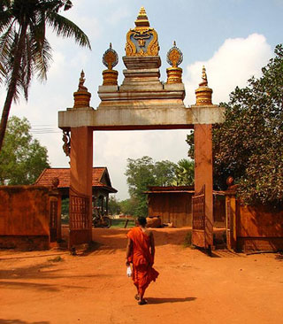
Preah Sihanouk Province, also known as Kampong Som, is a province in southern Cambodia on the Gulf of Thailand. This port city is a growing Cambodian urban center, located 185 kilometres (115 mi) southwest of the Cambodian capital, Phnom Penh. The province is named after King Father Norodom Sihanouk and grew up around the construction of Sihanoukville Port. Construction on the port began in June 1955 and it was the only deep water port in Cambodia. The port was built in part due to the waning power of the French leading to the Vietnamese tightening their control over the Mekong Delta and hence restricting river access to Cambodia. Sihanoukville's beaches have made it a popular tourist destination.
The province is served by Sihanoukville International Airport, 18 kilometres (11 mi) from downtown, although it has a limited commercial operation. The planned flights between Sihanoukville and Siem Reap may encourage visitors to Angkor temples in Siem Reap to extend their stay, though the crash of a charter flight in Phnom Damrey on 25 June 2007 from Siem Riep, has caused concerns.
Sihanoukville attracts tourists with its laidback beach atmosphere when compared to Thailand's more developed ones. However, the city has attracted not only tourists, but several NGOs and foreign and national investors in the last years in order to develop not only the growing tourist industry, but its capacity as an international sea port and other sectors like textile and real estate. In Sihanoukville is also located the main factory of Angkor, the Cambodian national beer.
Sihanoukville was the place of the last official battle of the United States army in the Vietnam War, although the incident took place outside Vietnam. It is known as the Mayagüez incident on May 12–15, 1975 between the US forces and the Khmer Rouge. Currently, visitors dive in Koh Tang, one of the Sihanoukville islands where the major battle to free the SS Mayagüez took place. Divers can see two shipwrecks 40 metres (130 ft) down.
On 22 December 2008, King Norodom Sihamoni signed a Royal Decree that changed the municipalities of Kep, Pailin and Sihanoukville into provinces, as well as adjusting several provincial borders.
Beaches
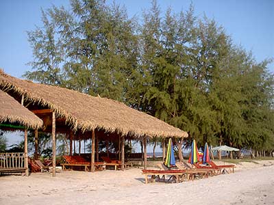
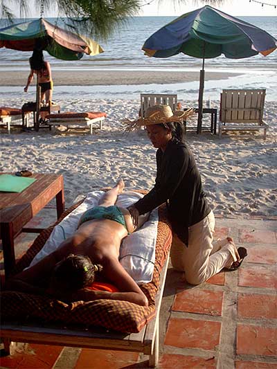
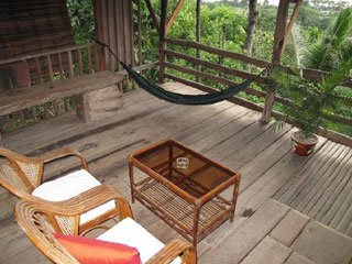
- Occheuteal Beach and Serendipity Beach: Occheuteal Beach is a long and narrow strip of beach lined with Casuarina trees, grass umbrellas, rental chairs and little drink huts. Many huts were bulldozed by the government to make way for a supposed new resort. This has raised concerns with human rights organizations. The northern section has become known as Serendipity Beach and is a popular beach with western tourists, noted for small guesthouse rooms right on the beach. Aside from these guest houses on the beach there are around 30 beach huts serving good value meals and a wide selection of drinks. Most popular huts along this stretch of beach are the Shore bar which hold regular beach parties. The sustainability of the Occheuteal beach was a primary consideration of various stakeholders, which brought about the development of a tourism development and management plan in 2005.[13]
- Otres Beach: Beyond a small headland at the south end of Ochheuteal is the similar Otres Beach.
- Sokha Beach: Sokha Beach is located just west of Serendipity Beach. This beach is privately owned by Sokha Beach Hotel, the first five-star luxury beach hotel in Cambodia. It provides many facilities with a wide white sandy beach, but hotel guards may prevent visitors who are not guests from going on to the beach.
- Independence Beach: Independence Beach is located next to Sokha Beach on its west. The beach was named after the old Independence Hotel. This beach offers a good stretch of clean sand. Situated at the northern end of the beach is Independence Hotel and Koh Pos Beach with a tiny island only 800m off the coast. Koh Pos is known for its rock strewn shoreline.
- Victory Beach: Victory beach is situated at the furthest north of the peninsula of Sihanoukville. It was the original backpacker beach and is still popular with budget travelers. At the northern end of the beach is located the deep sea port. Apart from white sand and blue sea, this beach offers a good spot to enjoy the sunset.
At the south end of Victory Beach is another small strand of sand called Lamherkey Beach. It is the place where a French/ Cambodian construction team laid groundwork for the construction of the new Port of Kampong Som during the 1950s. At this beach, you can hire a boat to nearby islands.
Islands
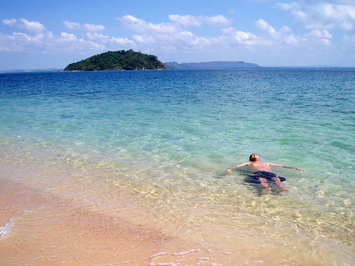
There are more than a dozen islands off the coast of Sihanoukville for tourists to hop around. Most of them are yet to be developed for an overnight stay with the exception of Bamboo Island or Koh Russei in Khmer. Many guesthouses, restaurants and cafes on Ochheuteal and Serendipity beaches offer trips and packages to these islands.
Soon Nail Island (also called Magic Island because it looks like a mushroom) will have a hotel run by the Russian owners of the Snake House. They already have a pier and most of the hotel and restaurant are finished.
- Koh Rong: It is situated west of the Sihanoukville coast. It offers the fantastic strand of beach on its southwest, stretching about 5 kilometres (3 mi). It has fresh water resources on the island and a bustling fishing community on the southeast with basic supplies including fresh water, fish and crab.
- Koh Rong Samlon: It is a bit smaller than Koh Rong and situated on its south. Beautiful beaches are on the east coast, where a large heart-shaped bay with some shellfish cultivation is located, and on the north shoreline facing Koh Rong. The marine life around Koh Rong Samloem is very diverse and offers some amazing diving.
- Koh Tang: It is located quite far from the main shoreline of Sihanoukville. Going there requires trippers to stay overnight on board. It offers interesting diving spots most of which are not frequently explored. The island is home to a military outpost and travelers should expect to be boarded by military personnel when out at the island.
Administration
For administrative purposes Sihanoukville is a municipality, holding the same status as a province. There is a provincial governor and three deputy governors. It is subdivided into 3 districts (Khan). The port has an autonomous administration.[20] The districts are divided in communes (22 communes in total).
The province is subdivided into 3 districts.
- 1801 Mittakpheap
- 1802 Prey Nob
- 1803 Stueng Hav
O’Cheuteal Beach
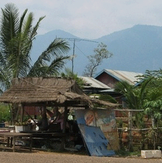
O’Cheuteal Beach is located in Sankat No 3. large and long with white sand and shallow water, it is the most popular beach in Sihanoukville, attracting many foreigners. There are a number of food stalls along the beach, in addition to fruit and seafood vendors.
Victory Beach

The land of beaches, Sihanoukville is an ideal destination for a dream holiday. It is located in the Southern part of Cambodia on the Gulf of Thailand. In fact it is the part of an area of land that projects out into the Gulf. Thus a majority of the Sihanoukville is covered by stretches of sandy area overlooking the absolutely gorgeous water bodies. It creates just the ambiance for you to simply sprawl about and also to enjoy a whole lot of adventurous activities. The Beaches of Sihanoukville have so many options that you can literally eat, drink and live there. One such activity packed beach in this area is Victory Beach in Sihanoukville.
“The Victory Beach in Sihanoukville”, the liveliest part of the town is one of the most popular Sihanoukville Tourist Attractions. It is situated right in the northern side of Sihanoukville, with the closest landmark being the Monument of Vietnam and Cambodia. Though the Victory Beach of Sihanoukville is a little far from the center of the town, finding your way to the beach side is not at all difficult and the ride is surely worth very bit. 
The Victory Beach in Sihanoukville actually covers a huge area and it is a rocky point that puts a pause to the endless stretch of white sand. It segregates the entire beach region into the northern and southern part. The southern region is even popularly known as the ‘Hawaii Beach’ and is more crowded with restaurants and cafés as compared to the other part. Thus the Victory Beach at Sihanoukville brings to you the perfect blend of serenity and amusement within the same vicinity.
Things to do in the Victory Beach of Sihanoukville
The Victory Beach in Sihanoukville in Cambodia has wide list activities for its visitors. It has a number of lovely restaurants serving delicious sea food for you to enjoy. You can even munch into some tidbits while watching the sun sink below the horizon or the movement of the ships near the port. Long walk by the water side is also a wonderful option.
Thus your Sihanoukville sightseeing will definitely not be complete without experiencing the fun and frolic of the Victory Beach in Sihanoukville. It is the place that will give you a picture of what Sihanoukville really is.
Ream Beach in Sihanoukville

The Ream Beach in Sihanoukville is the perfect place that takes you away from the crowded life of the town. Located on the outskirts it is almost a haven for nature lovers. It brings to you the best of creation and will surely captivate you to come back to it again and again.
Located at the farthest end of the town, you have to travel almost 20 Km before you reach the Ream Beach of Sihanoukville. Nevertheless this distance will seem nothing when you spend those priceless moments in a place which is nothing short of a paradise. The Ream Beach in Sihanoukville is not even difficult to reach because the road is pretty straight without much turns or twists. From the airport if you travel along the route 4 towards the northern part of Sihanoukville, you will come quite near this exotic water body. You will also get several public transports to ferry you to your destination.
The Ream Beach in Sihanoukville is a place that will bring you right in the middle of the untouched exquisiteness of nature. Being one of the brightest spots within the premises of the Ream National Park in Sihanoukville, it is usually haunted by the nature lovers. Though the area of the Ream Beach at Sihanoukville is not very large, it is truly one of the most charming among all the beaches in Sihanoukville. 
The Ream Beach in Sihanoukville in Cambodia is also one of the few beaches that are landscaped by mountains and water falls, thus making the entire scene a treat for the eye. Another major attraction of this beach is the swampy region of mangroves that grow right at the back of it. You can also see some lovely tropical birds while looking around the marsh area of the Ream Beach in Sihanoukville.
Apart from the exploration of so many fascinating things the Ream Beach in Sihanoukville is also ideal for simple relaxation. You can even see the fishermen at work while doing so. Since it is quite an uninhabited region you will only find few small stalls at this Sihanoukville sightseeing spot and it is advisable to bring your own refreshments
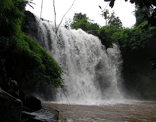
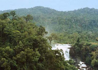
Kbal Chhay Waterfall

Locates at Khan Prey Nup in seven-Kilometer distance from the Sihanouk Ville Town, then turning left more nine-Kilometers by a red soil road. The waterfall of Kbal Chhay has many sources from the mountain rank at the seaside. The history of Kbal Chhay waterfall was found in 1960. Until 1963 Kbal Chhay arranged as the clean-water sources for providing to Sihanouk Ville, but the arrangement was failed became a hidden place for Khmer Rouge. In 1997, Kbal Chhay was changed to the developing zone. In 1998 Kbal Chhay was for bid by Kok An Company on constructing road and changing this site as tourist resort for local and international tourists. Nowadays, the Royal Government of Cambodia has changed this site as the clean-water sources for providing clean water to Sihanouk Ville.
The Kbal Chhay Waterfalls of Sihanoukville, Cambodia is actually a collection of 3meters to 5 meters high waterfalls which originates from different sources along the mountain ranges. However, only three out of the collection can be sighted. Besides being just a picturesque sight, the location of the Kbal Chhay Waterfalls in Sihanoukville is also a popular picnic spot where you can spend you day amongst the greenery and serene natural ambience of Kbal Chhay Waterfalls in Sihanoukville. The area also offers abundance of food and drink stand that drink stands for refreshments if you need any.
The Kbal Chhay Waterfalls in Sihanoukville can be easily reached from the main city center of Sihanoukville by taking the Route 4 north and then taking a turn at mile marker 217. This journey barely takes about 30 minutes. Boating of amazing natural beauty this is tourist attraction in Sihanoukville which is not to be missed. 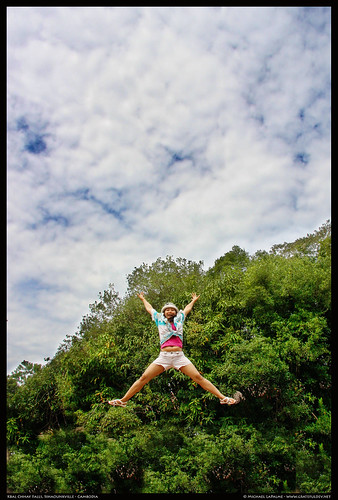
Koh Pos Beach (Snack Island)
This little beach is home to the rather oddly named Treasure Island Seafood Restaurant, and although not on an island, it’s certainly a treasure of a spot, with seafood that many an expat will tell you is the best in Sihanoukville. 
The sandy, well shaded beach here is small and secluded, with a few restaurant salas overlooking the water. Stuff yourself on seafood then go for a swim afterwards — what more could you ask for? Just watch out for the monkeys — as they won’t miss the opportunity to fiddle through your possessions while you’re twenty metres offshore.
The beach is named after Ko Pos (Snake Island) which lies just offshore. Ko Pos is best visited from Hawaii Beach, just around the headland from Ko Pos beach, where there are no shortage of boatmen who’ll whisk you over there. A trip out to Ko Pos is pleasant enough, but the beaches are nothing too magnificent.
Treasure Island Seafood Restaurant is an excellent option for a seafood lunch, with the crab a real stand out. Arrive early to grab your own seaside sala rather than getting stuck in the restaurant proper. The menu is endless, but anything in the pepper sauce is pretty good. Be wary of taking a table too far from the restaurant as the hillock is home to a bunch of cheeky monkeys. Moderately priced so long as you don’t eat too much crab. Commonly recommended by expats as having the best seafood in Sihanoukville. Recommended.
Treasure Island Seafood Ko Pos Beach, Sihanoukville. Tel: (016) 876 618. Open daily, 10:00-22:00.
Koh Russei
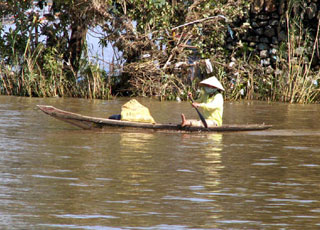
Though only an hours boat ride from Sihanoukville, Ko Russei is a world away from the manicure/massage/bracelet-toting touts of most mainland beaches. At Ko Russei, there are only golden sands, fishermen’s boats offshore, and a cluster of antique Russian guns strategically placed between the beaches. A former navy base that’s just opened to tourists, this island’s serene character is set to change rapidly. Russei’s population hovers around 30, including a dozen navy officers who do more lounging about than surveying of the seas. “Russei” means “Bamboo” in Khmer, and the centre of the island is chock-full of it. 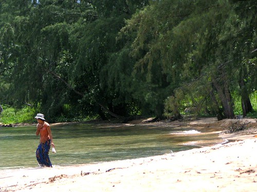
Most travellers discover the place on one of the ubiquitous Three Island Boat tours which all go to the same islands (Ko Ta Kiev, Ko Craloh, and Ko Russei) for mediocre snorkeling and a great seafood lunch. These set tours all have unpredictable levels of service and safety. Once they’ve seen Russei, many travellers want to come back and stay a while, and for those who have – or make – the time to stay here, it’s often an unexpected highlight of their travels in Cambodia.
There are currently two resorts of basic wooden bungalows on Russei, one on each beach of this small island. Tourism is such a recent phenomenon here, neither beach seems to have a name yet. Bamboo Island Resort, which faces the mainland, is owned by a Vietnamese family who hosts seafood barbeques for the Three Island Tours. Ko Ru Resort is on the sunnier side of the island, ideal for sunset-spotting and whiling away as many hours as one can get away with. It’s a western-owned and -managed place, run by the Bar Ru Guesthouse in Sihanoukville. The ten-minute walk between beaches is pleasant one; they’re connected by a path that traverses the island through a jungly forest filled with deafening cicadas.
Russei gives the visitor a rare sense of isolation and tranquility in this part of the world. It seems nearly untouched, though inevitably that will change quickly. It remains to be seen how the navy and the government will manage tourism here. Still, for the moment, Ko Russei is, for all who see it, a pleasant surprise. A highly recommended destination in Cambodia; get here to experience its serenity while you can.


 Semi-precious gems and Khmer Loeu handicrafts and artifacts are Banlung’s main souvenir offerings. The handicrafts are uniquely authentic – as likely made for use by local people as for the souvenir market – ‘back-strap baskets’, fabrics, gourd vessels, gongs and more. There is one souvenir shop in town located in the first row of shops in front of Phsar Banlung. The gem and drink shops on the corner next to the central monument have a few souvenirs, especially gourd vessels and baskets. Terres Rouges Lodge has just opened a boutique offering handicrafts and Cambodian silks.


 For the time being, Pursat receives few travellers and the two main attractions, the Cardamoms and the Tonle Sap require a little initiative on the tourist’s part to visit. Pursat is predominantly accessible by the National Highway No 5 form Phnom Penh (174km) and Battambang (106km). There is also an old slowly train working between Phnom Penh and Battambang, which stops outside (2km) from Pursat.
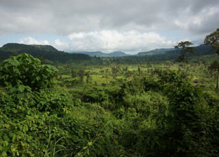
 Check the Koh Kong chapter for information on the fried from Koh Kong to Pailin, which cuts through the Cardamom Mountains on the western edge of Pursat province. The Cardamom Mountains of Koh Kong and Pursat provinces are said to be the most pristine wilderness area remaining in Southeast Asia. This ride takes you through the area.
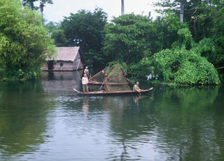


 The resort of Ba Phnom has been planned to develop as a big tourist attraction at the eastern part of Mekong River because this area can attract most visitors during the Cambodian festivals and holidays. In addition, there are more 15-attractive sites in Prey Veng province such as: